
<< Back to Flood Risk Management main page
Flash flooding from heavy rainfall is one of the most common natural hazards facing DC residents. Summer thunderstorms can overwhelm the District’s storm sewer system, leaving homes, businesses, and roadways vulnerable to flooding.
To better understand and reduce flood risk, the District launched the DC SensorNet Program, a partnership between the DC Homeland Security and Emergency Management Agency (HSEMA), the Department of Energy and Environment (DOEE), DC Water, and the District Department of Transportation (DDOT), and funded through a Federal Emergency Management Agency (FEMA)’s Hazard Mitigation Assistance program grant.
The SensorNet program, in partnership with Hyfi, is installing weather station sensors on rooftops and flood sensors on or in storm drains, sewer manholes, and over roadways and rivers throughout all eight wards of the District. The rainfall and flood depth data collected by these sensors will be crucial to city leadership seeking to mitigate and respond to flood risk.
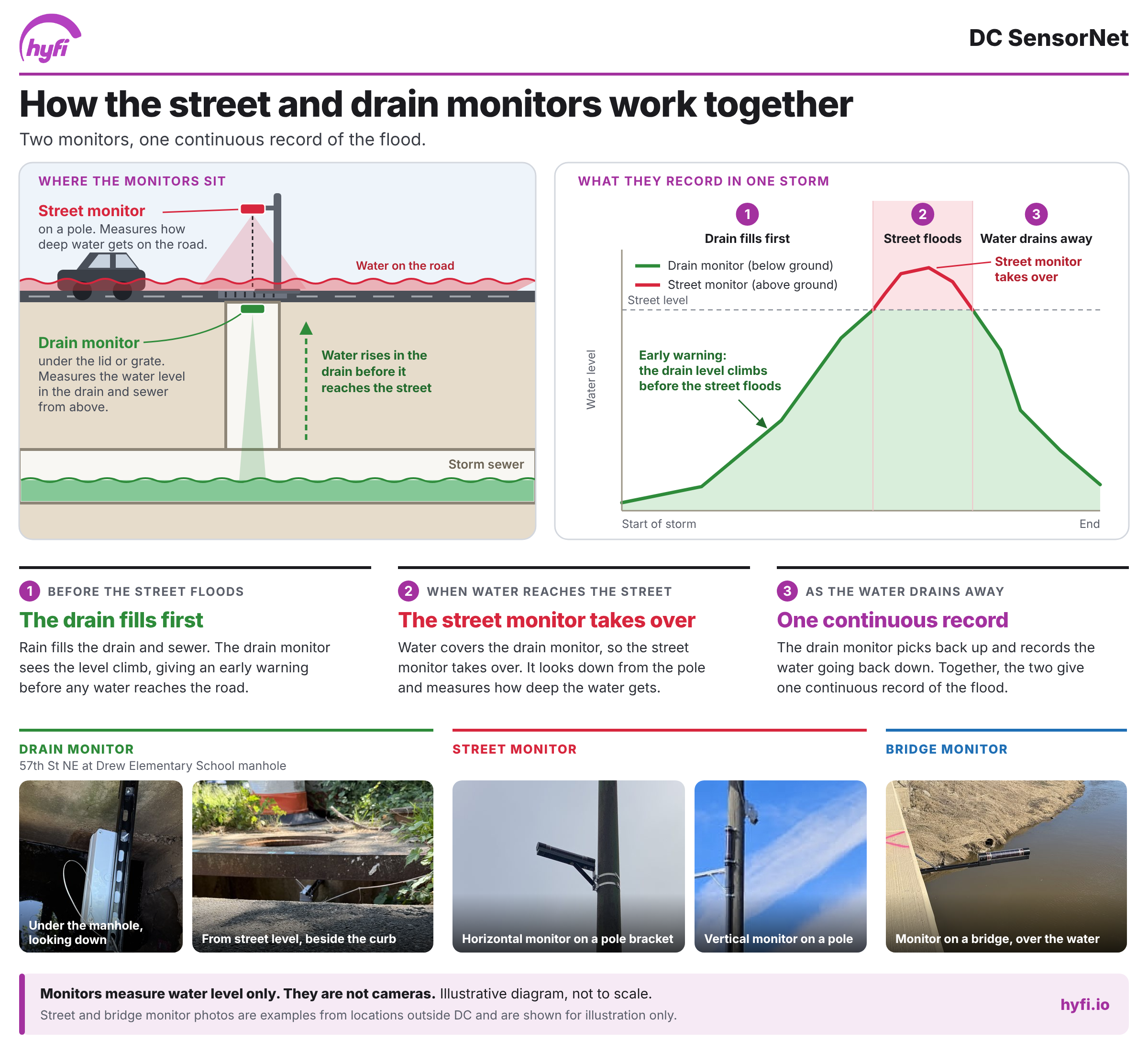
What does the equipment look like?
As SensorNet is installed, residents may notice small pieces of equipment attached to existing infrastructure, such as poles. This equipment is part of a larger monitoring system and works with nearby sensors to collect and transmit information about rainfall and flooding conditions.
Why did the District pursue this program?
Flooding is one of the most frequent natural hazards facing the District.
While the District has studied flooding from the Potomac and Anacostia rivers extensively, flash flooding from intense rainfall can be harder to understand and predict. In developed areas, rain runs off rooftops, streets, sidewalks, and other hard surfaces into the sewer system. During intense storms, the system can become overwhelmed and cause street-level flooding.
SensorNet gives the District more real-world information about what is happening during these events.
How will the District use the information?
- Improve flood models
Real-world rainfall and flood information can be compared with existing flood models to help the District better understand where and how flooding occurs.
- Plan infrastructure improvements
Better information can help planners and engineers understand where flooding is happening and inform future improvements designed to reduce flood risk.
- Better understand extreme weather
Weather stations on government and other public buildings will collect rainfall, temperature, humidity, wind, and other weather information. This can also help the District better understand extreme weather conditions, including extreme heat.
- Support emergency management
Real-time flood and weather information can improve situational awareness and help the District explore ways to make faster, more informed decisions during flooding events.
Where will the project occur?
Flood sensors and weather stations will be installed at selected locations across all eight wards of the District.
What happens after the pilot?
DC SensorNet is currently a pilot program. The District will use what we learn to determine how the network could be used or expanded in the future.
Project Partners
DC SensorNet is led by HSEMA in partnership with DOEE, DC Water, and DDOT, with funding from FEMA. Technical and implementation support is provided by All Hazard Consortium, Arcadis, and Hyfi.